Heat lows
The phenomenon
Heat lows or heat troughs are prominent climatological features of many arid land areas of the world during the warmer months, especially at low latitudes where insolation is strong. These areas include northern and southwestern Africa, west Pakistan and northern India, the Qinghai-Xizang plateau in China, southwestern North America, Saudi Arabia, the Iberian Peninsula and northwestern and northeastern Australia. A list of pertinent references is given by Rácz and Smith (1999). Heat lows or heat troughs are sometimes referred to as thermal lows or thermal troughs, respectively, and they are comparatively shallow disturbances, generally extending up to the depth of the convectively well-mixed layer (typically 3-4 km).
Heat lows and heat troughs have many dynamical features in common. The distinction in a surface isobaric chart can depend on the isobar spacing, where the former has at least one closed isobar while the latter has the form of an open wave. Both types of disturbance may be thought of as localized regions of enhanced low-level cyclonic relative vorticity that are linked to horizontal gradients of diabatic heating.
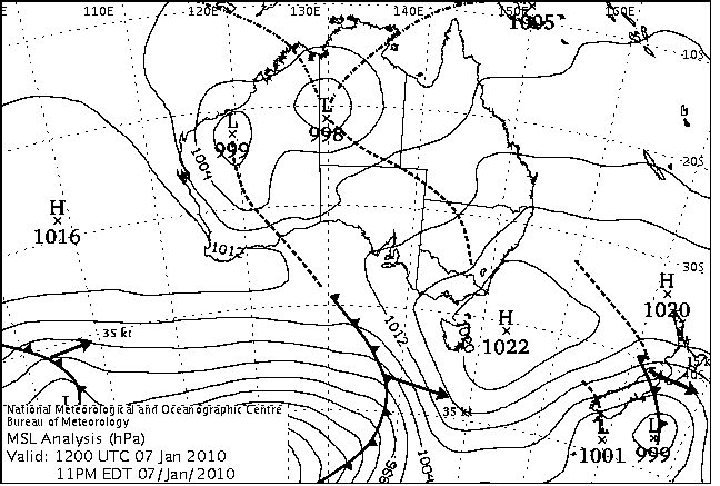
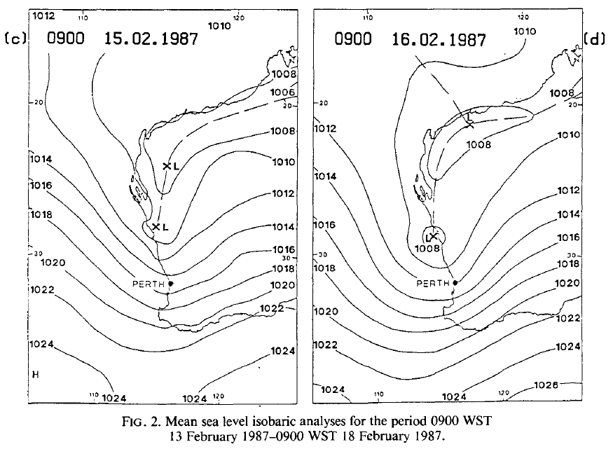
Our own work was motivated mainly by the desire to understand the inland heat trough over Queensland and the heat lows of central and northwestern Australia, although an early study was concerned with the heat trough over Western Australia. The inland heat trough over Queensland appeared relevant to understanding the origins of southerly morning glory cloud lines. Figure 1 shows a mean sea level chart of the Australian region with a prominent heat low over Western Australia.
 (a) (a)
|
 (b) (b)
|
 (c) (c)
|
The West Australian heat trough: a simple model
Perhaps the feature of Perth's climate most appreciated by the summertime visitor is the frequent arrival of the afternoon sea breeze. This southwesterly breeze is known locally as the "Fremantle doctor" because it blows from the port of Fremantle, some 15 km to the southwest of the city. It provides welcome relief from maximum temperatures that average almost 30°C through the summer, and often exceed 35oC for periods of over a week. Shorter spells in the low 40s are common also.
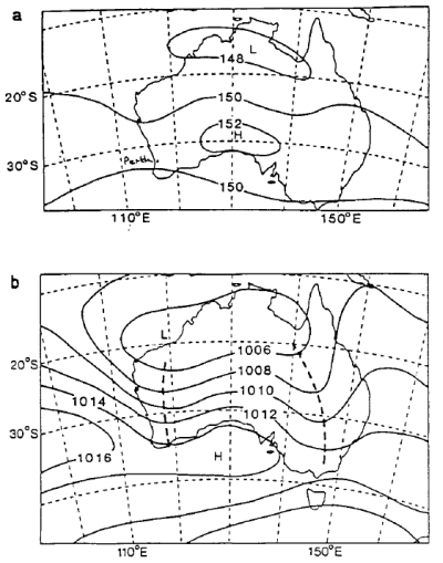
The reason for these high temperatures is that, during the summer, much of the Australian subtropics lies between the subtropical ridge and the monsoon trough and is thereby under the influence of an easterly wind regtme as shown in Fig. 1. Perth is located on the westcoast and so, when not in a sea-breeze regime, it receives air that has spent several days over the hot arid continental interior.
 (a) (a)
|
 (b) (b)
|
The easterlies contain two significant troughs. One ts located to the east of the Great Dividing Range along the east c oast of Australia and heads southwards from the Cloncurry region in central Queensland. The other lies generally inland of the west coast in the mean, but shows considerably greater amplitude and day-to-day variation in position than the eastern trough.
The importance of the west coast trough to Perth's summertime temperatures lies in its effect on the sea breeze. It is widely recognized that when the trough is offshore, then the sea breeze, if it develops at all, will be weak, will arrive in the late afternoon, and will fail to penetrate very far inland. In any case, the result is a hot day for the coastal communities. If conditions conspire to keep the trough offshore for several consecutive days, the result is a heat wave. On the other hand, when the trough is inland, a vigorous sea breeze develops comparatively early in the day. In this case, the maximum temperature will be near or below average.
Following a case study of an interesting sequence of days relating to this phenomenon, we developed a simple one-layer model to examine aspects of the west coast trough (Kepert and Smith 1992). ...
The dynamics of heat lows: basic studies
Motivated by our observations over northeastern Australia, Rácz and Smith (1999) carried out idealized numerical model simulations to investigate the evolution and structure of a heat low over a square flat island surrounded by sea. Two important findings were:
-
The heat low has a minimum surface pressure in the late afternoon or early evening following strong insolation of the land, while the relative vorticity is strongest in the early morning hours following a prolonged period of low-level convergence. Thus the heat low is not approximately in quasi-geostrophic balance.
-
The low-level convergence is associated with the sea breeze and later with the nocturnal low-level jet.
These findings corroborated with observed features of the heat lows over Australia (e.g. Preissler et al. 2002) and are supported by recent observations of the Saharan heat low. Indeed, they go some way also to explaining the observed diurnal cycle of the West African monsoon circulation (Parker et al. 2005 and references).
Two other findings relevant to using potential vorticity thinking (Hoskins et al. 1986) to understand heat lows were:
-
Although a cyclonic vortex, the heat low is characterized by an anticyclonic potential vorticity anomaly relative to its environment on account of the greatly reduced static stability in the convectively well-mixed boundary layer.
-
As a result of the reduced static stability in the mixed layer, the horizontal components of relative vorticity and horizontal potential temperature gradient make a non-negligible contribution to the potential vorticity in certain flow regions.
Rácz and Smith (1999) investigated also the effects of differing land area and Coriolis parameter on various aspects of the heat low, but gave little attention to the overlying anticyclone. In a subsequent paper, the two authors extended their model to examine the effects of orography on heat low formation and structure (Reichmann and Smith, 2003) and an extension of the model to examine the effects of a simple background flow were carried out by Spengler et al. (2005).
The cycle of diabatic heating and cooling of the atmosphere in the numerical model was accomplished using the Mellor-Yamada 2¼-parametrization scheme for the boundary layer (Mellor and Yamada, 1974) in association with surface heating or cooling. After long integration times, this scheme leads to unrealistic mixed-layer depths because the only mechanism for cooling to oppose the et heating of the atmosphere is that which occurs in a shallow layer adjacent to the surface. In an effort to remove this limitation, Reichmann and Smith (2003) incorporated the radiation scheme proposed by Raymond (1994) in the model. This scheme is based on a grey atmosphere approximation and allows the atmosphere to cool, thereby preventing the long-term growth of the mixed layer. Reichmann and Smith (2003) used the new formulation to study the heat low that forms over elevated terrain.
Effects of a simple background flow
Calculations for a heat low in simple background flows were carried out by Spengler et al. (2005). Like the case without a background flow, the flow shows a significant diurnal variation in which the sea-breeze circulations are a prominent feature during the daytime and the nocturnal low-level jet is a prominent feature at night. If the land area is large enough so that the sea breezes do not cover it entirely during the diurnal cycle, strong convergence associated with the low-level jet leads to the formation of intense, but shallow, cold fronts along the inland boundaries of sea-breeze air. These fronts decay rapidly after sunrise when surface heating leads to renewed vertical mixing, which destroys the low-level stable layer.
The presence of a uniform easterly flow leads to the formation of a west-coast trough, similar to the situation commonly observed over Western Australia. The trough broadens during the day due to the heating of the land, while at night it sharpens and again frontogenesis occurs at low levels near the leading edge of the sea breezes to form shallow cold fronts. In this case there is an east-west asymmetry in the sea-breeze circulations: the cool air behind the west-coast sea breeze is shallower than that behind the east-coast sea breeze, but the vertical circulation associated with the west-coast sea breeze is deeper. The east-coast sea-breeze front penetrates further inland, but is more diffuse and is recognizable more by its signature in the relative vorticity than by that in the horizontal temperature gradient.
The presence of a horizontal shear-flow leads to the deformation of the heat trough, a process that appears to play an important role in the formation of cold fronts over central Australia. Again the calculations show the formation of shallow fronts over the land during the night, which frontolyse rapidly after sunrise. Despite the idealized nature of the calculations, the associated patterns of low-level vorticity, divergence and horizontal temperature gradient that develop overnight show remarkable similarity to those observed over central Australia.
An improved numerical model
During the course of the foregoing study, Thomas Spengler discovered some errors in the model initialization and in the numerical implementation of the radiation scheme by Reichmann and Smith (2003) and also errors in Raymond's (1994) paper. The errors in the initialization were found to have a negligible effect on the results presented by Reichmann and Smith and those made in the implementation of the radiation scheme had only a small impact. However, \textbf{they} motivated the development of a new idealized model with an improved radiation scheme (Spengler and Smith 2008). This new model was run with a higher horizontal resolution than the original version and used to investigate additional dynamical aspects of the structure and evolution of a heat low over a subcontinental- or continental-scale circular island. These aspects included:
-
the development of an upper-level anticyclone, and
-
the degree to which the cyclonic and anticyclonic circulations are in gradient wind balance.
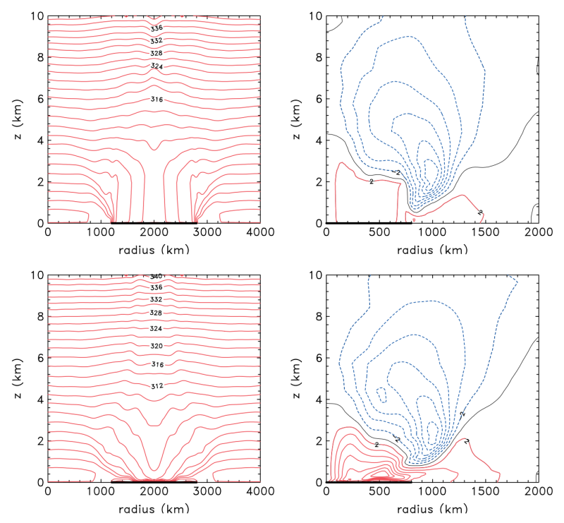
Figure 3a shows height-radius cross-sections of potential temperature and tangential wind speed in the late afternoon (1700 h) on day 11 in the calculations for a circular island of radius 800 km. At this time, the effects of insolation are near a maximum. The potential temperature field shows a mixed layer (characterized by the depth of the region of uniform potential temperature at the centre of the domain of just over 4 km, a value that is typical of inland soundings across central Australia. The low-level winds are cyclonic and relatively light at this time, not exceeding 4 m s-1. The most striking feature of the azimuthal wind field at 1700 h is the anticyclone, which has a maximum wind speed of over 12 m s-1 at heights between about 2 and 3 km in the case with a radiation scheme. Interestingly, this anticyclone extends throughout much of the troposphere, although it decreases in strength with height in the upper troposphere. This decay is consistent with slightly cooler air overlying the heat low, assuming thermal wind balance.
|
|
|
Animations of flow evolution
Some basic features of the heat low can be seen in the following animations:
Evolution of the radial flow and potential temperature click here avi 132 Mb
Evolution of the tangential flow click here avi 99 Mb
Evolution of the vertical velocity click here avi 90 Mb
Spengler and Smith op. cit. showed that the upper-level anticyclone extends through much of the troposphere, but has its maximum strength in the lower troposphere, just offshore. It exhibits relatively little diurnal variation when the heat low reaches its mature stage; much less so than the low-level cyclone. The anticyclone develops steadily over a period of a few days and is associated with the return (offshore) branch of the sea-breeze circulation in the lower troposphere and a slow diurnal-mean outflow in the middle and upper troposphere. The outflow at upper levels may be interpreted as a mean drift induced by upward-propagating inertia-gravity waves that are initiated by the inland-penetrating sea-breeze front during the afternoon and evening.
Unlike the heat low, the upper anticyclone is largely in gradient wind balance, except in the neighbourhood of this gravity wave. The gravity wave has a significant effect on the radial and vertical components of the motion field at any one time and time averaging is required to isolate more thoroughly the steady-state structure of these components. In a mean sense one can distinguish between distinct patterns of the tangential flow component between midnight and noon, when the low-level cyclone is strongest, and between noon and midnight when it is much weaker.
These differences reflect the strong turbulent mixing of momentum in the mixed layer over land during the afternoon, which leads to a significant weakening of the cyclone, and the formation of a strong low-level jet at night, which re-amplifies the cyclone circulation.
Spengler and Smith showed also that there is a strong analogy between the dynamics of heat lows and to certain aspects of the dynamics of tropical cyclones, which have a warm core, a shallow unbalanced boundary layer, and which are surmounted also by an anticyclone. Principles governing the absolute angular momentum budget are the same as those relating to the tropical cyclones and to the zonal-mean flow over Antarctica. Implications of these principles for obtaining a realistic steady state in long-term integrations of axisymmetric models are discussed.
The effects of orography
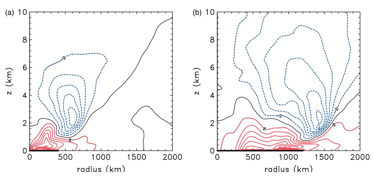
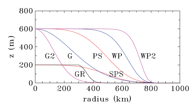
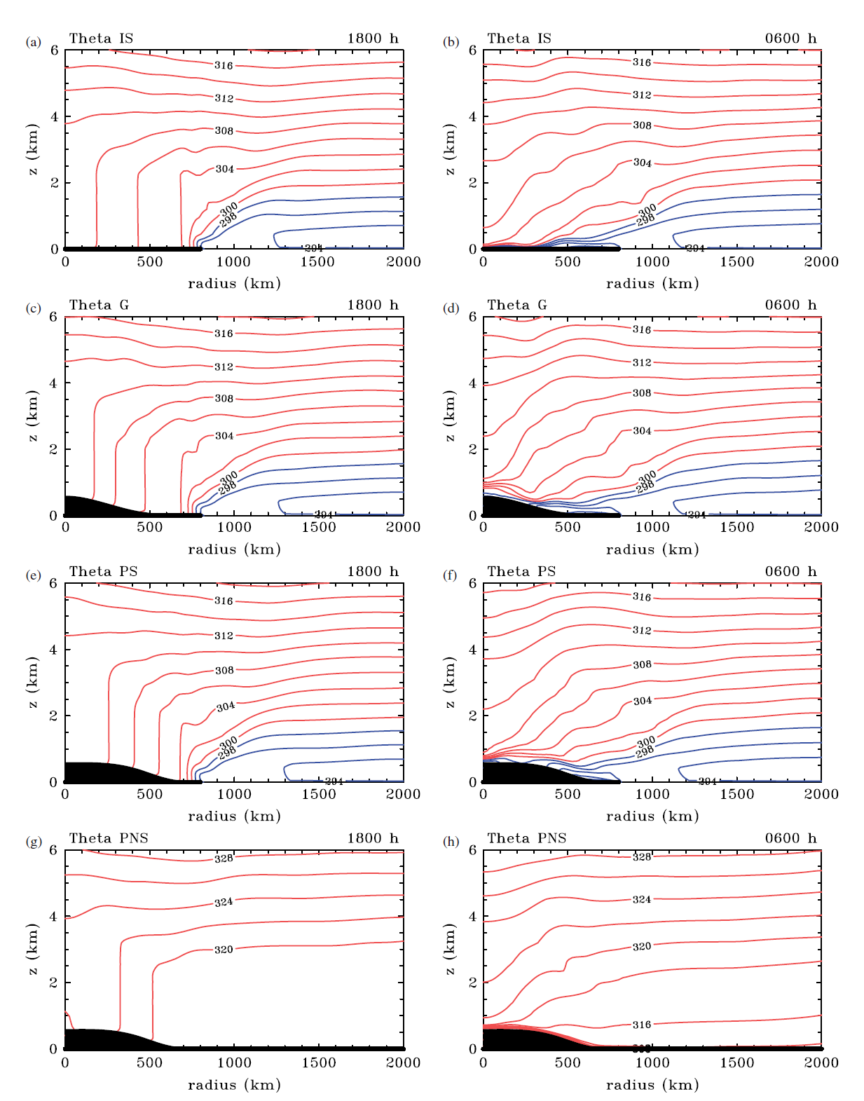
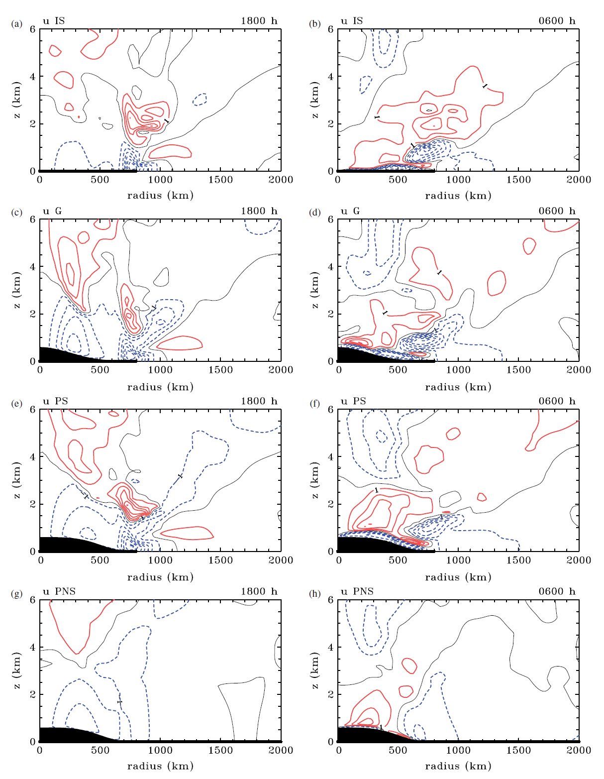
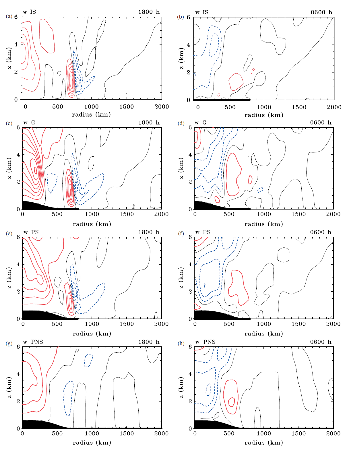
In a second paper, Smith and Spengler (2010) investigated orographic effects on the dynamics of heat lows, again in an idealized flow configuration. The behaviour of the heat low that forms over a plateau-like orography on a circular island is compared with that when the island is flat, and that when the plateau is surrounded by land instead of sea. In all cases, a broad-scale, negative radial gradient of potential temperature forms in the daytime mixed layer over land. The presence of orography enhances the broad-scale baroclinicity over the orographic slope due to the identical heating of a column of air with a reduced mass, i.e. lower surface pressure. In the absence of sea, the baroclinicity is solely confined to the slope of the orography.
The broadscale potential temperature gradient results in an overturning circulation in the lowest few kilometres, which is separate from the shallower and more intense sea breeze circulation in the island cases. The presence of orography leads to a stronger overturning circulation via enhanced baroclinicity. In the case without sea, both the overturning circulation and tangential circulation are closely tied to the orography. The overturning circulation advects absolute angular momentum inwards to spin up the low-level circulation, despite some frictional loss of angular momentum enroute. During the night, radiative cooling over the land leads to a strong nocturnal low-level jet that amplifies the spin-up process. During the daytime, the cyclone weakens as the angular momentum is convectively mixed through a deep layer.
|
|
|
|
Animations of flow evolution
Evolution of the radial flow and potential temperature: comparison of flat island with one with a plateau click here avi 117 Mb
Evolution of the radial flow and potential temperature: comparison of flat island with land with a plateau click here avi 110 Mb
References
Hoskins, B. J., M. E. Mcintyre, and A. W. Robertson, 1985: On the use and significance of potential vorticity maps. Quart. J. Roy. Meteor. Soc., 111, 877-946.
Kepert, J., and R. K. Smith, 1992: A simple model for the West Australian Heat Trough. Mon. Wea. Rev., 120, 2042-2055.
Mellor G, and T. Yamada, 1974. Hierarchy of turbulent closure models for planetary boundary layers. J. Atmos. Sci., 31, 1791-1806.
Parker, D. J., R. R. Burton, A. Diongue-Niang, R. J. Ellis, M. Felton, C. M. Taylor, C. D. Thorncroft, P. Bessemoulin, and A. M. Tomkins AM. 2005. The diurnal cycle of the West African Monsoon circulation. Quart. J. Roy Met. Soc., 131, 2839-2860.
Preissler, M., M. J. Reeder and R. K. Smith, 2002: A case study of a heat low over central Australia. Aust. Meteor. Mag., 51, 155-163.
Rácz, Zs., and R. K. Smith, 1999: The dynamics of heat lows. Quart. J. Roy. Met. Soc., 125, 225-252.
Raymond, D. J., 1994. Convective processes and tropical atmospheric circulations. Q. J. R. Meteorol. Soc. 120, 1431-1455.
Reichmann, Zs., and R. K. Smith, 2003: Terrain influences on the dynamics of heat lows. Quart. J. Roy Met. Soc., 129, 1179-1194.
Spengler, T., M. J. Reeder and R. K. Smith, 2005: The dynamics of heat lows in simple background flows. Quart. J. Roy Met. Soc., 131, 3147-3165.
Spengler, T., and R. K. Smith, 2008: The dynamics of heat lows over flat terrain. Quart. J. Roy Met. Soc., 134, 2157-2172
Smith, R. K., and T. Spengler, 2011: The dynamics of heat lows over elevated terrain. Quart. J. Roy Met. Soc., 137, 250-263.
Copyright © Roger Smith, Date 06 Feb 2015